This is a review of the iOS and iPadOS app called “The Photographer’s Ephemeris,” from Crookneck Apps. The Photographer’s Ephemeris is a photography planning application, specifically an app for planning landscape photography involving the sun or the moon. Recall for a moment Ansel Adam’s celebrated photograph of “Moon and Half Dome” taken in Yosemite National Park, California; the photograph shows the moon just off the face of Half Dome, a granite rock formation, in a particular position that creates a nice composition. If you wanted to recreate that photograph today, how would you do it? Camp out in Yosemite 13 times a year at the time of the full moon, and spend all day waiting for the moon to get in position?
No, you would buy The Photographer’s Ephemeris, spend 10 minutes planning the shot, and drive out to Yosemite on the day, hour, and minute when the alignment was to your liking and take your photograph. So, the problem to be solved is, how do you efficiently plan a landscape photograph involving the sun or the moon so that on the day you go to the location the sun or moon is in the right place? That is the problem that The Photographers Ephemeris solves.
There are two main inputs you must supply to the app: where do you want to stand with your camera, and where is the primary landscape feature that you want to include in your composition? The primary output of the app is a list of dates and times that meet your requirements.
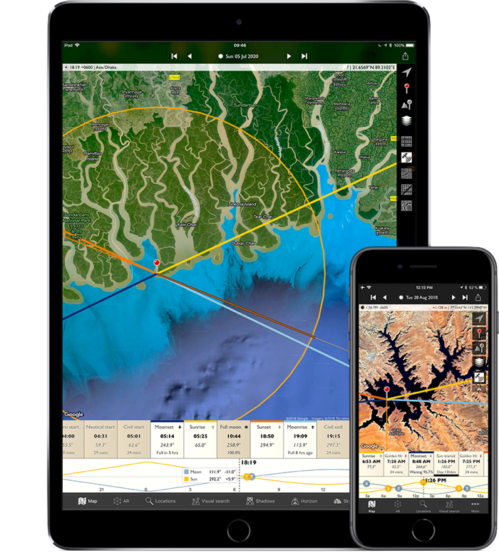
As you might expect, the primary user interface elements of The Photographer’s Ephemeris (or TPE, for short) are a map and a timeline to choose a time. Actually, there are several maps that you can use in the app: Apple Maps, Google’s map, Open Street Maps, a topographical map, and even a satellite photo view.
You interact with the map in the usual ways: you can search for something by name, you can swipe on the map to move around, and you can pinch/unpinch to zoom out or zoom in. Things get more interesting once you place a red pin on the map for camera location and a grey pin for the landscape element of interest. Once you do that, TPE understands the distance and height difference between the two points and will show you a cross-sectional view of the landscape elevation between the two points.
One nice feature is that this cross-sectional view also predicts what parts of the terrain between the two pins will be observable from the camera location; solid portions of the line mean that the intervening feature is observable, while dotted lines indicate portions of the cross-section that lie on “the backside of a hill.”
Now all you have to do is specify a time. The time control is a double ribbon below the map; one strip is annotated with various interesting celestial moments, such as sunrise, moonrise, the start of civil twilight, etc; there are many different celestial events to choose from. The other ribbon is the actual timeline and shows sinusoids that represent the procession of the sun and moon in the sky.
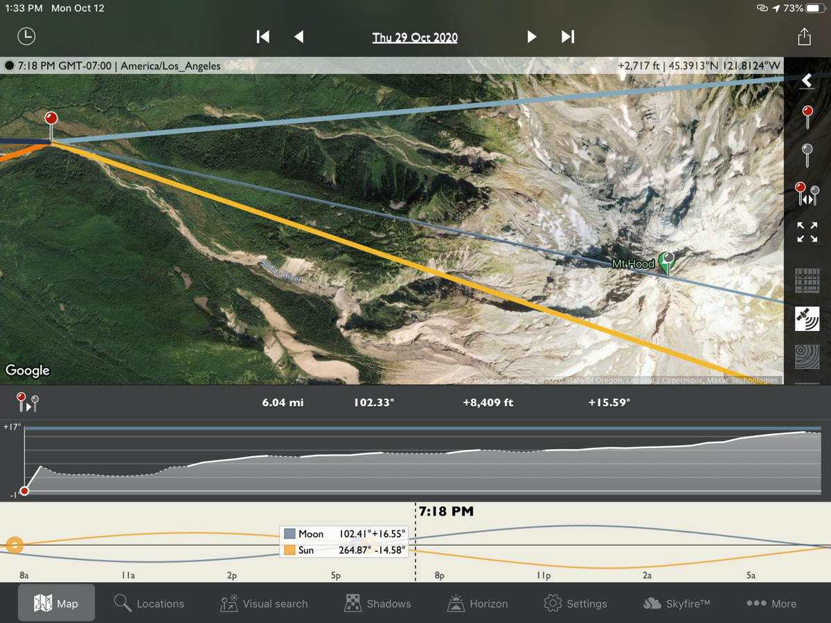
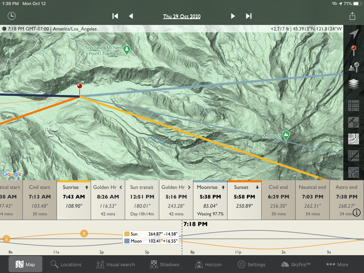
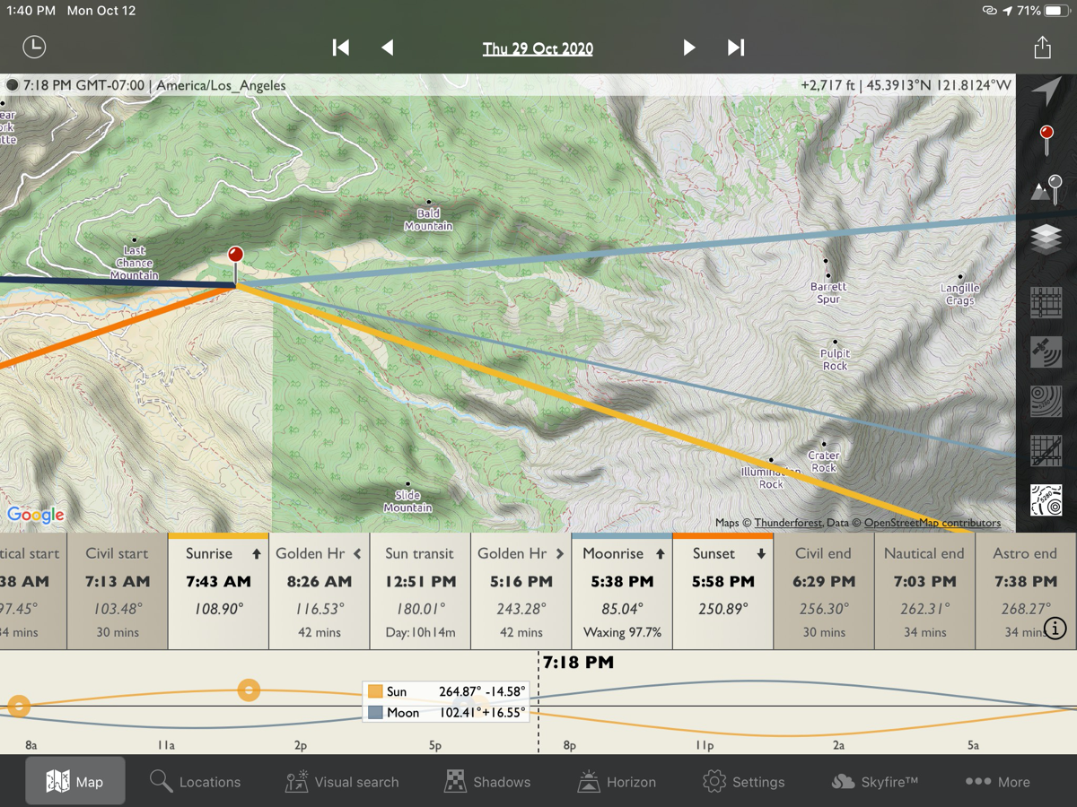
By swiping on the timeline you can advance or retard the virtual clock, or by tapping on a named celestial event you will set the clock to that event directly. If you have previously placed a red pin representing the camera position, the azimuth angle of the sun and moon will be represented by lines emanating from the red pin camera location, while the elevation of the sun will change on the cross-sectional view below.
As you swipe the timeline to change the time, the lines representing the sun and moon sweep around from east to south to west relative to your camera position, so you can predict the angle of the sun or moon at any desired moment at a particular point on earth. Of course, all of the outputs of celestial object azimuth and altitude angle are given numerically as well, so you can use TPE for unusual situations involving buildings of a certain height, etc. You can jump ahead by days, or even manually choose a specific day and time.
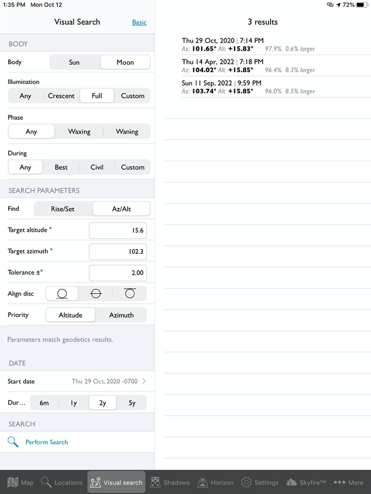
The real power of the Photographers Ephemeris, however, lies in its search capability. Once you have set a red pin for camera location, and a grey pin for a landscape feature, you can tap on the search tab and it will bring up a sheet of search parameters. The most important parameters, azimuth and elevation angle, will be carried over from the map view (but you can tweak them here as well); the other must-choose parameter you must set is whether you’re interested in the sun or the moon’s position.
There are also several minor tweaks you can adjust on the search page, such as whether to give priority to azimuth or altitude during the search, what tolerance in angle you can live with, etc. Then when you tap the search button, TPE will advance forward in virtual time to find the days/hours/minutes that meet your search specification. The search results will come in the form of a list, with the closest match results annotated with an asterisk. Tapping on a list item will set the main map interface time so that when you change back to the map view you can tweak the timing if necessary to position the sun above or to the side of your landscape element.
The app has useful housekeeping features, such as the ability to name and save locations, or export a setup to your calendar, email, or another person via messages or email.
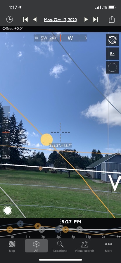
For devices that support it, the app can do an augmented reality display of the path of the sun or moon. This only works at the location where you are standing, however – you can’t project yourself into arbitrary locations a la Google Street Maps and look around.
The app also has a tie-in with an extra-cost service called SkyFire that helps predict when the weather is going to be especially interesting for sunrises and sunsets. One thing that I particularly appreciated about the developer is that he has posted a series of video tutorials on Vimeo that will help you master the app successfully.
So, how well does it all work? I think that the app is well-designed and intuitive to use. It’s priced reasonably at $9.99 in the iOS App Store, and a single purchase allows you to use it on both iPhone and iPad. It doesn’t do every possible task in preparing for a landscape photograph, but it does do the crucial job of helping you find when the sun or moon will be in relationship to a landscape feature that you’re interested in photographing.
It’s worth mentioning that TPE is one of a trio of apps put out by Crookneck; perhaps when I’ve had a chance to evaluate the others I’ll post another review. I would say that the main practical limitation of the app is that it works best if you have been in the area already once, and wish to plan a subsequent trip.
For instance, on a recent hike to Ramona Falls on Mt. Hood we crossed the Sandy River at one point, and I looked east up the river bed to where the peak was off in the distance; I was curious about when the full moon might appear over the shoulder of the peak, and when I got home I did a search on The Photographers Ephemeris. If you’re out on the Ramona Falls trail on Thursday, October 29th at 7:18 pm, say Howdy!
Links:
- Developer website: photoephemeris.com/…
- The Photographer’s Ephemeris in the App Store: apps.apple.com/…
- Support videos: vimeo.com/…

